Click here to access the Google Doc of these resources.
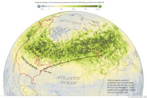
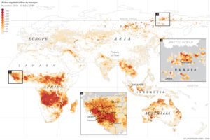
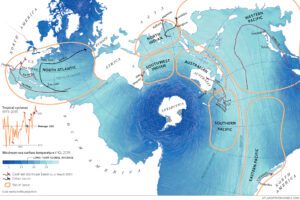
This map reveals the extent of vegetation fires that burned between October 2018 and October 2019. These fires were detected by a NASA satellite – you can see the real time map here.
Guided reading
Quote 1: ‘…the magnitude of fires in the American West has only increased.‘
What does magnitude mean?
Why is this important?
Quote 2: ‘…while slash-and-burn farmers and ranchers have ignited forests…‘
What is slash-and-burn?
Why might this be happening?
Quote 3: ‘…heat turned forests into tinder; drying peatlands became underground fuel.‘
Which area of the world was this happening in?
Why is this so alarming?
Quote 4: ‘Smoke plumes extended to Alaska, carrying more carbon into the sky that June than Belgium emits in an entire year.‘
Where is this carbon coming from?
Why is this a problem?
Quote 5: ‘…’zombie fires’ smoldered in the soil over winter and reignited come spring‘
Why is the term ‘zombie’ used here?
Why are ‘zombie fires’ such a worry?
Highlight the names of places mentioned in the text.
Use the Burn Scars map to mark these places on this outline map.

True or false?
Answer these questions before you look at the Burn Scars map, then check your answers against the map to see if you are correct.
| True or false 1 | True or false 2 | |
|---|---|---|
| There are large numbers of active vegetation fires shown along the Equator | ||
| There is only one area of the UK that had more than 10 active vegetation fires from Nov 2018-Oct 2019 | ||
| Active vegetation fires are rare in the Sahara Desert | ||
| It is too cold for active vegetation fires to be a problem in Siberia | ||
| A band of intense vegetation fire activity runs across the Sahel (south of the Sahara Desert). | ||
| Active vegetation fires are only a problem in the centre of Australia, not by the coast. | ||
| There are more hexagons representing 200+ fires between Nov ’18 and Oct ’19 in Africa than in South America. | ||
| The Amazon Rainforest is too wet for fires. | ||
| There are few active vegetation fires shown on the Plateau of Tibet. | ||
| There are no active vegetation fires shown in Greenland. |
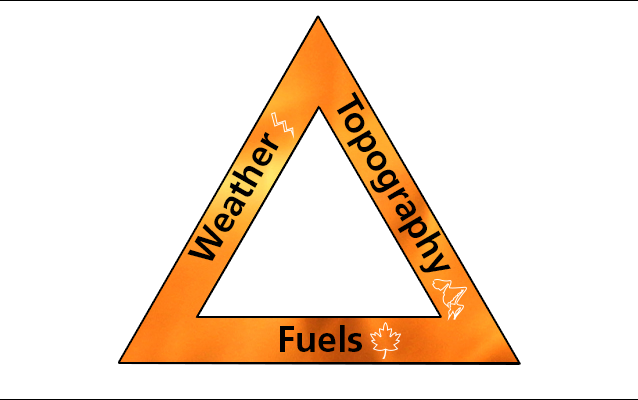
Can you think of reasons to explain any of these patterns? Think about how they relate to the wildfire triangle and note your ideas here:
For more information about the wildfire triangle see here.
To what extent do you agree with these statements?
President Bolsonaro Amazonia is a resource to be plundered rather than protected
To what extent do you agree with this statement?
Justify your view here:
Australia is a rich country and will be able to manage its wildfires in the future
To what extent do you agree with this statement?
Justify your view here:

Burn scars – not so positive feedback!
When the carbon cycle moves out of equilibrium (balance) it can be affected by two types of feedback:
Positive feedback – moves the cycle further away from equilibrium
Negative feedback – moves the cycle back towards equilibrium
This means that positive feedback isn’t a good thing!
Look at the information about active vegetation fires in Siberia. How does this show a positive feedback cycle?
Draw a diagram to show this positive feedback cycle.
How could negative feedback be used to help tackle this problem?
Additional Materials
Click here for materials on how to take action to stop the world burning.