Click here to access the Google Doc of these resources.
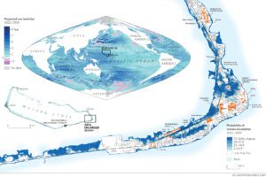
Look at the world map on the Treading Water graphic that charts projected sea level rise. As the key shows, areas marked in purple show where the sea level is projected to drop, whereas areas marked in blue show projected sea level rise. This map clearly shows that sea levels are projected to change at different rates and in different ways around the globe.
Give three examples of places where sea levels are projected to fall.
Example 1:
Example 2:
Example 3:
Give three examples of places where sea levels are projected to rise by between 0 and 3 feet.
Example 1:
Example 2:
Example 3:
Give three examples of places where sea levels are projected to rise by between 7 and 9 feet.
Example 1:
Example 2:
Example 3:
‘Sea level rise doesn’t happen uniformly across the Earth. Ocean currents, weather patterns and variable rates of warning can all make a difference. Island groups in the western Pacific Ocean face a greater threat than those in the eastern half of the Pacific.‘
The location of the Marshall Islands is marked on the Treading Water world map. Describe the pattern of projected sea level rise in this location.
The Marshall Islands consist of over 1000 islands. One of these is Majuro Atoll. Majuro City is the capital of the Marshall Islands; Majuro is a coral atoll and consists of 64 islands surrounding a lagoon. Laura is the highest point in the atoll, but is still less than 10 feet above sea level.
What problems is Majuro likely to face as sea level rises?
If you are in Europe you may be wondering why the measurements on this map are in feet – this is one of the units of measurement for distance used in the USA, alongside inches, yards and miles.
Guided reading
Quote 1: ‘The Marshall Islands are resilient‘
What do you understand by the term ‘resilient’?
Why is it important for places to be resilient?
The Marshall Islands fell under the control of the US in 1947. Give one example of a negative impact and one of a positive impact of this relationship using the text.
Quote 2: ‘the nation of more than a thousand islands is now contending with the cascading onslaught of the climate crisis‘
What is meant by ‘cascading onslaught’?
Why do you think the author has used the term ‘climate crisis’ rather than ‘climate change’?
‘Those who remain sense that their future is being stolen.’
Who is stealing the future of the Marshall Islanders?
Why is this being allowed to happen?
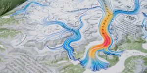
Majuro Atoll
Look at the Treading Water map of the western section of Majuro. The blue shading shows the probability of marine inundation (flooding by the sea) between 2020 and 2100. Key buildings are shown in orange.
Estimate the proportion of the section of island shown on the map which has a 75-100% probability of marine inundation by 2100.
How many of the key buildings shown in orange are in areas where there is a 75-100% probability of marine inundation by 2100?
How is this careful land use planning likely to help Majuro’s resilience (ability to bounce back from difficulties)?
‘Whilst the capitol and other key structures were built on higher ground, Majuro – the sea of government for an entire archipelago – can’t function if its major roads, bridges and residential areas are underwater.‘
To what extent do you agree with this statement? Justify your view.
What next for the Marshallese?
At the 2019 UN Climate Change Conference, then President of the Marshall Islands, Hilda Heine said:
‘“It’s a fight to the death for anyone not prepared to flee. As a nation we refuse to flee. But we also refuse to die.‘
Roughly a third of Marshallese have fled to the US. The Marshall Islands has a Compact of Free Association with the USA, but the distance between them is over 9000km and migrants face adjusting to a very different culture.
Marshallese remaining on the atoll face many challenges, including the threat of drought. The Majuro Water and Sewer Company collects water from the catchment on the International Airport runway and supplies water for 12 hours daily. The atoll has a tropical rainforest climate, so there is plenty of rain, but it is challenging to store and distribute clean water.
If the Marshallese are to remain on their islands in the long term, a combination of climate change mitigation and adaptation will be needed.
- Mitigation – reducing or preventing greenhouse gas emissions
- Adaptation – adjusting systems to cope with changes
Entrepreneurs in Majuro Atoll have been experimenting with using coconut oil instead of diesel on the island. This would improve energy security, provide a market for farmers and reduce problems of diesel emissions. However, changes need to be made across the globe to make a significant difference to greenhouse gas emissions; the Marshallese can’t do this on their own.
Sea walls are being built and improved as the islanders try to adapt to changing sea levels. They are considering dredging material from the surrounding reef to make some islands higher or to make a new island, but this would have a serious environmental impact and is also expensive.
To read more about this issue see here.
Check your understanding:
- Why have so many Marshallese fled to the US?
- Why don’t all Marshallese move to the US?
- What is the difference between climate change mitigation and adaptation?
- How are the Marshallese trying to mitigate and adapt to climate change?
- Why won’t the Marshallese be able to mitigate climate change on their own?
Take things further:
- How could the story of the Marshallese be used to raise awareness of the impacts of climate change and associated sea level rise?
- How could this story inspire people, businesses and governments to change their systems to reduce greenhouse gas emissions?
- What obstacles could get in the way of these changes being made?
- How could these obstacles be overcome?