London Cycle Hire and Pollution
As a cyclist in London you can do your best to avoid left turning buses and dozy pedestrians. One thing you can’t really avoid though is pollution (althou...
As a cyclist in London you can do your best to avoid left turning buses and dozy pedestrians. One thing you can’t really avoid though is pollution (althou...

The above map (and this one) was produced using R and ggplot2 and serve to demonstrate just how sophisticated R visualisations can be. We are used to seeing sim...
If I said a country was 1594719800 metres squared it would mean a lot less to you than if I said it was about the size of Greater London (so long as you ...
I have been using R (a free statistics and graphics software package) now for the past four years or so and I have seen it become an increasingly powerful metho...
It would be a shame to end the year without a festive map! Jack Harrison (@jacksfeed) is studying for a research masters in “Advanced Spatial Analysis and...
I have spent the last few years investigating the geography of family names (also called surnames). I work with the team who assembled the UCL Department of Geo...
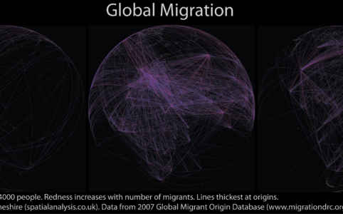
As 2011 draws to a close it is worth reflecting on what, I think, has been a defining year for mapping and spatial analysis. Geographic data have become open, b...
Transport for London have just released their performance data (link here) for the London Underground network. It is in the form of a really detailed file that ...
This week I am giving a talk on some of the London maps that we produce in CASA. The hours of work I put in to such maps is minuscule compared to the amount of ...
Last week I attended a “Beyond 2011” Census event organised by the Prof. Dave Martin and the Office for National Statistics (ONS). The attendees cam...