James Cheshire
About
Blog
Teaching
Papers
Category:
Featured Maps
London Cycle Hire and Pollution
Feb 2, 2012
The Power of Comparison: Just How Big Is It?
Jan 16, 2012
Mapped: Christmas Around the World
Dec 20, 2011
The Best of 2011
Dec 6, 2011
Just how far can the Tube take you?
Nov 22, 2011
Mapping Academic Tweets
Oct 10, 2011
Naming Rivers and Places
Aug 26, 2011
Mapping GCSE Scores
Aug 16, 2011
Flattening the Earth
Mar 7, 2011
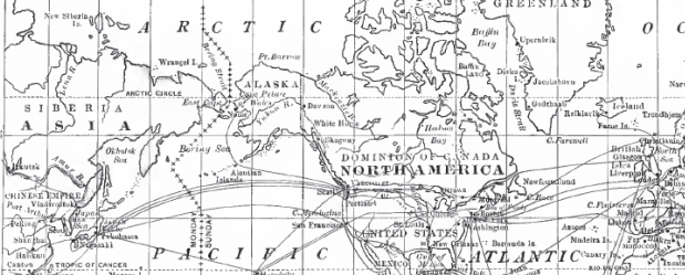
World Transport Links and US Climate from The National Geographic over a Century ago
Mar 2, 2011
Previous Page
1
2
3
4
Next Page